Route
·The Witney Railway.
·Yarnton (3¾ miles from Oxford)
Built as a junction on the Oxford Worcester & Wolverhampton Railway, with the London & North Western Railway.
The Witney and East Gloucestershire railway had a junction from Yarnton at the stations western end.
The station had two platforms which were stone faced with a very basic wooden station building on the north platform which was more like an enlarged shed than a station building, there was also a small metal shelter on the southern platform.
When built the station had two signal boxes, and a station house close to the line at the western end.
There was no goods shed here and there was no direct road access to the station.
Various additions were made during WW2, including a large marshaling yard consisting of 9 sidings and a turntable to the south of the station, after the war the station retained these facilities.
|
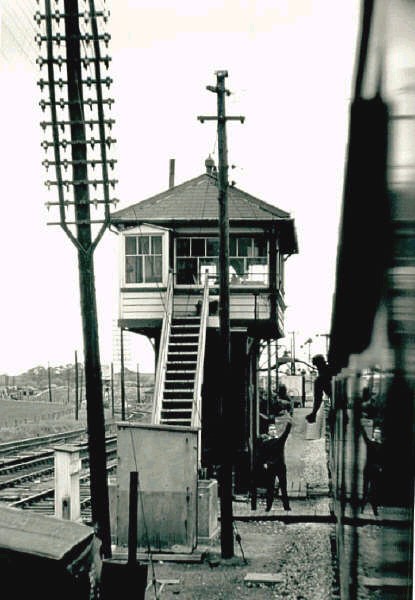
Token exchange at Yarnton Signal box, facing toward Worcester, with the Fairford branch off to the left.
12th June 1962. Tony Newman |
· Cassington (1 mile 220 yard from Yarnton)
Opened by the Great Western Railway on the 9th March 1936, Cassington halt had a small concrete platform with a wooden shelter. The halt was situated on the north side of the line to the east of the village, having originally been sited on the other side of the road.
Immediately after leaving Cassington the line passed under a substantial stone bridge carrying the A40 road.
Three quarters of a mile from Cassington the line crossed the River Evenlode on a large plate girder bridge approximately 80 feet long, and then a short distance from that, it crossed the Cassington canal.
Half a mile before Eynsham the railway passed the site of a sugar beet factory that had its own internal railway and locomotive. This opened in 1927 but closed in 1931, then reopened during WW2 as a Royal Army Service Corp. depot., extra sidings being added.
After this the railway passed under a plate girder sided bridge that carried the Eynsham to Oxford Road.
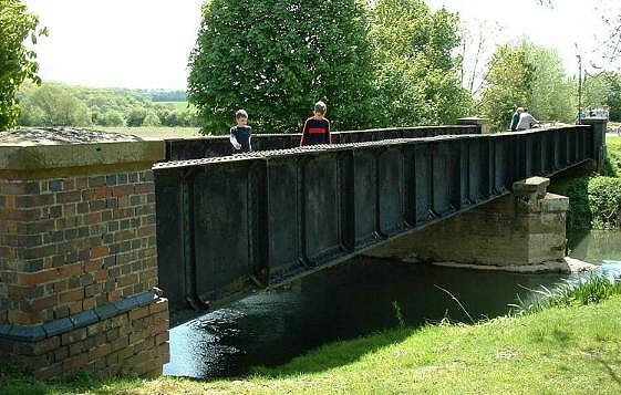
Bridge over the river Evenlode between Cassington & Eynsham
5th May 2003
David M Howse
5th May 2003
David M Howse
· Eynsham (3 miles 594 yards from Yarnton)
Eynsham station was located to the south of the village. On approaching Eynsham Station the route crossed a level crossing, carrying the Eynsham to Stanton Harcourt road, passing the station masters house on the north side before entering the station.
On the north side of the line was a stone faced platform with a wooden station building, next to which on the platform stood a signal cabin. (A GWR addition of 1892)
Behind the platform there was a large stone built goods shed, beyond that cattle pens and a goods yard, with another 2 loops and a siding.
In 1944 the station gained a passing loop on the south side opposite the original platform with a second concrete built platform and a small platform shelter.
|
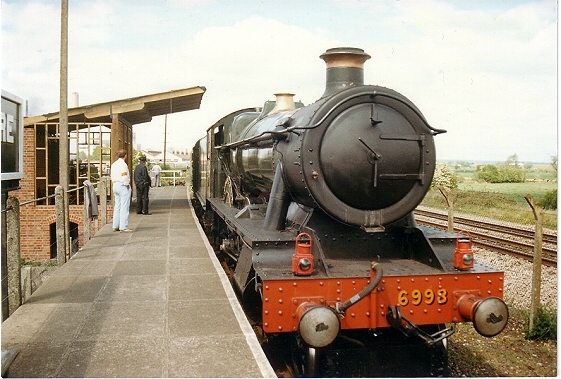
Eynsham platform at its new home at
The Didcot Railway Centre, with Ex Great Western Railway ‘Modified Hall’ class, 6998 “Burton Agnes Hall. (The Building being erected at the time this photo was taken is a Didcot Railway centre addition) David M Howse |
|
Just under a mile before reaching South Leigh the line passed over a bridge, built to give local farmers access to their fields.
It was a brick built structure that was later found to be to small for modern traffic and filled in, replaced with a crossing being built a short distance closer to South Leigh.
· South Leigh (5 miles 814 yards from Yarnton)
South Leigh, located at the southern end of the village, was entered over another level crossing, passing the crossing keepers cottage on the south side.
Its facilities included a stone faced platform located on the north side, with a smaller version of the usual Witney Railway wooden station building, and at the back of the platform there was a cattle dock, small parcel shed and a weigh bridge, It also had 2 Ground frames in small sheds one at each end of a run round loop.
During WW2 a food storage depot was built to the west of South Leigh, the loop being extended to serve this.
Before reaching Witney the railway passed under a substantial stone bridge, carrying the Cogges to Stanton Harcourt lane. Locally called the Ballaso (Named after the ballast hole, a quarry built by the railway company's contractors to extract gravel for the lines construction).
· Witney Junction
The line then carried on for about 1 mile before crossing the first of three bridges over the River Windrush, then the line divided in two, this was the point where the East Gloucestershire Railway extension joined the Witney Railway, being located 300 yards east of Witney's later Passenger station, to the right the Goods station which when the line was first built was the Witney Railway terminus station and to the left the Passenger Station built by the East Gloucestershire Railway Co. as a joint passenger station. After the junction the two lines then crossed over two more bridges (one on each line) over the second stream of the Windrush, all three bridges were metal girder plate construction. The bridges where strengthened possibly during WW2 with concrete filled sandbags round the base, the bridge leading to the goods yard had a foot bridge down the upstream side of the bridge.
· Witney Goods
Witney goods station, located behind St. Mary's church, north of a park area known as the Leys, it was the largest station on the line; original built as the terminus station of the Witney Railway, there were a total of seven sidings, a large goods shed, which was later added to with wooden extensions on both ends. A stone faced platform with a wooden station building used as a parcel office, this had been the original Witney railway Co.'s passenger station building, next to which was a large corrugated metal shed built after the stations conversion to a goods station.
It also had a cattle dock, and originally an engine shed. (Demolished approximately 1900).
There where also various sheds that served the local Blanket mills (Witney's main export), a stable block later used to house motor vehicles and a timber store.
It also had a station house just beyond the buffer stops, which was the last station house built by the GWR.
· The East Gloucestershire Railway
· Witney Passenger station (7 miles 220 yards from Yarnton)
Located to the south of the Leys park, it was built by the East Gloucester railway, it had a loop with 2 stone built platform faces, with a stone station building, similar in design to other East Gloucestershire railway station buildings, but with a canopy and an extension to the rear, next to Station building on the platform was a signal box and a GWR pagoda shed.
The other platform had a small wooden shelter, and a water crane located on the western end of the platform.
At some time both platforms where extended eastwards.
Just beyond the end of the platforms the line past under the first of the East Gloucestershire bridges.
These where small with stone abutments with wooden or metal decking and parapets, with a dip in the line under them to save on earthworks.
At some point this bridge which carried the Witney to Ducklington road (Station lane) was strengthen with one of the abutments and the decking being replaced, on the other side of the bridge there was a small end loading dock and siding on the north side and a water tower and permanent way huts on the south side.
A short distance to the west of the station, the line crossed over Queen Emma’s dyke on a small girder bridge, and about 200 yards beyond that passed under another standard EGR bridge carrying the Witney to Ducklington road.
The line then carried on curving south west, passing under two more small bridges, one under the Ducklington to Curbridge road and the other carrying the Bampton to Curbridge road at Lew.
· Bampton (11 miles 1452 yards from Yarnton)
Located about 1¾ miles north of the village, was reached by passing under another bridge carrying the Brize Norton to Bampton road.
In 1944 the station was renamed Bampton & Brize Norton.
It had two stone faced platforms, one (on the south side) had the usual EGR stone built station building and a large signal box built by the GWR.
The other platform (on the north side) had a small wooden shelter like the one at Witney (EGR), on the same side as the main station building there was a small stone built goods shed and platform, also cattle pens and a weigh bridge. On leaving Bampton the line crossed two of RAF Brize Norton's aircraft taxi ways, a temporary siding was laid at Bampton on October 22nd 1936 while RAF Brize Norton was built.

7404 & 7412 at Carterton with the
14.25 Fairford to Oxford. 11 June 1962.
Gerald T Robinson
14.25 Fairford to Oxford. 11 June 1962.
Gerald T Robinson
· Carterton (12 miles 396 yards from Yarnton)
Opened on the 2nd October 1944, to serve the nearby RAF Brize Norton and RAF Broadwell, Carterton was only 1 mile 704 yards from Bampton, again this station was reached by the line passing under a standard EGR bridge, carrying the Carterton to Black Bourton road.
The station was simple affair with only a passing loop and two platforms. The station building was nothing like any other on the line, being built from concrete blocks. There was a small shelter on the other platform. It had no goods facilities or sidings but it did have a ground level GWR signal box.
· Alvescot (13 miles 1628 yards from Yarnton)
Only a short distance from Carterton, the line passed under the usual EGR bridge, carrying the Alvescot to Black Bourton road.
The station had a stone faced platform on the south side of the line. The station building was built to the familiar EGR design but uniquely was built of brick rather than the local stone, also on the platform was a GWR pagoda.
The station had no passing loop just a loop that passed in front of a small brick built shed that served as a goods store, it also had a cattle dock.
A short distance after leaving Alvescot the line passed under a bridge which carried a small lane that ran into fields to the south east of the line.
· Kelmscott & Langford (16 miles 66 yards from Yarnton)
After passing under another standard EGR bridge, carrying the Kelmscott to Langford road, the line entered the station, opened on the 4th November 1907 by the GWR, it had only an enlarged corrugated iron pagoda as a station building, on a brick Faced platform.
It had no goods shed or loop just a siding to handle the goods traffic and a cattle dock, both added on the 9th July 1928.
1¾ miles after leaving Kelmscott & Langford the line crossed the Little Faringdon to Kelmscott road on a level crossing, which was controlled, by a small signal cabin in the garden of the crossing keepers cottage.
Then a short distance further the line crossed over the river Leach, into Gloucestershire on a plate girder bridge.
· Lechlade (18 miles 836 yards from Yarnton)
Located to the north of the village and built on the south side of the line, Lechlade station had the usual EGR stone built building and a signal box on a stone faced platform, with a goods loop, sidings, goods shed, and a cattle dock.
During WW2 Lechlade gained an extended passing loop and a new goods siding.
Immediately after leaving the platform the line passed under a standard EGR bridge and headed towards Fairford - the lines terminus.
· Fairford (21 miles 1254 yards from Yarnton)
Built over a mile to the east of Fairford as a through station, it was spread over a long, narrow site.
It was reached after passing under the Fairford to Lechlade road on an EGR built bridge.
On the north side it had a stone built platform and EGR design station building, also on the platform was a signal box.
The station's other facilities included a Large goods shed, cattle dock, goods loop and sidings, it also had a 90 foot long wooden built GWR engine shed and a turntable, again improvements were made during WW2 with Fairford receiving extra goods sidings.
The Fairford branch was unusual among branch lines, in that the locomotives were usually turned at Fairford and so usually ran chimney first.
Thanks to Gerald T Robinson, Tony Newman & D. K. Jones For the use of their Photographs,
Please respect their copyright.
Please respect their copyright.
